 |
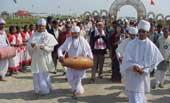
| Arvind Dave, Governor of Arunachal Pradesh, being welcomed by Sattriya dancers on the second day of the North-Eastern Cultural Festival at Majuli recently. Picture by UB Photos |
Unemployment, land scarcity and lack of resources pose a greater threat to Majuli than erosion
l The writer is professor of history at Dibrugarh University
Of late, Majuli — popularly believed to be the largest riverine island in the world — has begun to draw global attention. If an Internet site on “island superlatives” is to be believed, the sobriquet belongs to Ilha do Bananal, a 20,000 square km island formed by two river channels of the Araguaia river of Brazil. Lending credence to the website’s claim is the Centre’s admission that there is no “official evidence” of Majuli’s girth being the largest among all river islands of the world.
Created centuries ago through the changes of the courses of the Brahmaputra and its two tributaries, Majuli, situated in Assam’s Jorhat district, encompasses an area of about 460 square kilometres.
On the north of this island flows the old streams of the Brahmaputra — the Luit and the Kherktia Suti — and on the south lies the Brahmaputra. That Majuli had always been a large island is evident from the beginning of its known survey, the first of its kind done by British officer John Peter Wade in the last years of the 18th century. Writing in the middle of the 19th century (1853), A.J. Maffatt Mills, judge of the Sadar Dewani Adalat, Calcutta, who visited Assam in 1953, reported that “the area of Majuli island covered some 2,82,165 acres of land”.
The history of Majuli’s creation is obscure. On the basis of traditions it was once believed that Majuli was created by large depositions made by the Brahmaputra. Researches done on the subject, however, show that the island was created by changes in the courses of the three rivers — Dihing, Dikhow and the Brahmaputra. There is no doubt that changes in the river courses were the effects of depositions, but the entire events that led to the creation of this historic island testify to the fact that the island was born not by deposition alone. A major part of the island was actually formed by a sliced-out portion of landmass lying to the south of the old Brahmaputra.
The character of the island — an amalgam of sand (deposition) and clay (hard soil of the south) — is still apparent; most of its southeastern territories consist of the sliced-out landmass that is being washed away by erosion. Almost the entire remaining part presents the bed of a dead river course with layers of sands and sediment, buried reeds, innumerable ponds and dead river channels criss-crossing each other.
The prelude to this historic event lay in the process of shaping up of the southern slice into the form of almost an island surrounded by a course of Brahmaputra and its two southern tributaries — the Dihing and the Dikhow.
Then came the second great event of change. The course of the Dihing slowly petered possibly due to natural process and deposition at its mouth. This led the river to merge with the Dikhow which then fell into the Brahmaputra at Kaliabor in Nagaon.
At this time, as pointed out by Sir Edward Gait, the Brahmaputra “flowed down the course of what is now called the Lohit river along the north of the Majuli island, while the Dihing followed the present channel of the Brahmaputra to the south of it and after receiving the waters of the Disang and the Dikhow united with the Brahmaputra as its western extremity”. Thus the land mass lying in between the Brahmaputra and the Dihing-Dikhow combined to take shape of an island, with the half-dead mouth of the Dihing specifying the boundary on the east. The third and the final stage was extraordinary and reflects nature’s secret power to create and destroy.
The channel of the Brahmaputra then flowing on the north of the sliced-out land mass faced a natural blockade in its own deposition, leading major volumes of water to be channelised along the course of the Dihing-Dikhow probably by breaking through the dead mouth of the Dihing. This event finally shaped the land mass into an island, gradually making it larger with the addition of almost the entire dead bed area of the great river to the north in subsequent times.
The change of course of the Dikhow and the Dihing happened centuries back, prior to at least the 13th century when the powerful Ahom prince, Sukapha, established a small state in the extreme southeastern corner of the Brahmaputra valley. The process of drying up of the major channel of the Brahmaputra on the north of the island was also geological and took centuries to complete, at least not before the establishment of the great Vaishnava monasteries (satras) in the middle of the 17th century.
All records of the monasteries point to the fact that they were established on the north bank of the Dihing and south of the Luit (old Brahmaputra). The final scenery, however, came not long afterwards; the small and shallow channels of the Brahmaputra falling into the Dihing through its dead mouth gradually widened and in course of time carried the main stream into the Dihing making it the new course of the great river. This resulted in the drying up of its old course almost totally and the sandy land mass thus created on its bed added to the island’s northern territorial span.
On the basis of traditions handed down generations and supported by historical evidence of major earthquakes bringing in astounding natural and geographical changes in Assam, it can be presumed that this great and significant event took place some time in the last part of the 17th or early 18th century.
It is to be noted that in spite of Majuli being identified as an island it was never a single one; in fact, it is still a combination of a number of islands — big and small. Some were once so big and distinct that J.P. Wade mentioned them as “districts”. Being situated between rivers of great magnitude, and, therefore, rarely frequented by people from outside in the early centuries, the ambience was one of astounding calm and quiet.
This atmosphere was more or less prevalent till the Sixties when immigrants from erstwhile East Pakistan (now Bangladesh) and the natural growth of the population unknowingly began to invade this beautiful kingdom of nature. Majuli is, therefore, after half a century, a dry and thickly populated area of poor and landless peasantry.
Majuli is now neither well-known for its curd and milk, nor for its abundant supply of fish for which it was once famous. Its economy is dependent on agriculture and shopkeeping without much resources. Neither has it been possible to revive the old crafts like wood and bamboo works and silk production, chiefly endi. In the name of building roads and embankments to facilitate communication network and investment for the sake of its territorial protection, Majuli, however, provides a haven for contractors and their powerful partners.
This island — not merely a geographical entity — has been confronted with a number of problems, mainly geographical and economic. Continued floods and erosion by the Brahmaputra poses a major threat to its physical existence. From past experience and on the basis of geological research it may be contended that the river can face a serious threat from the Subansiri river in the near future rather than from the Brahmaputra. In either case, there is hardly any possibility of this great island vanishing from the map due to the erosion by the Brahmaputra, now the cry of the Majuli protection programme.
The more serious problem is its growing unemployment, land scarcity and lack of resources, which has not only shattered the hospitable nature of its people, but has brought gradual devastation of its virgin cultural settings. In the face of growing urbanisation and without much resources, there is bound to be a crisis; and this is where the real problem lies. The solution lies in its economic development, the key to which, in turn, lies in making it a world heritage centre.